May 22, 2016

Day 7 - On Land Recreation and alternate uses of teapots; Rod


It was a day of recreation for Quijote crew.  It started with a marathon sleep-in.  Bob and I had a day long hike in mind that the books described as steep, slippery, and difficult - just what we needed to shake our limbs out of a week of lethargy.  Since the route was described as a couple of hours each way, there was clearly no need to get going early.  We slept in, had a leisurely breakfast, and relaxed the morning away.  Then discovering that the day was getting away from us, we mustered quickly and Kay ferried us to shore.

Charging up the trail, it started off easy, then disappeared. We continued following what trail remained but it kept getting steeper until we found ourselves hanging off a moss covered wall with dead trees and decaying roots as our only hand holds.  A faint path clearly forged ahead, but my inner voice was telling me we were off route, following others who had no inner voice.

We turned around, worked our way back, and found the real trail, wide and lovely.  As advertised, it was steep in places, and certainly strenuous, but anyone who is accustomed to climbing in the Cascades with a good pair of boots would not find it difficult.

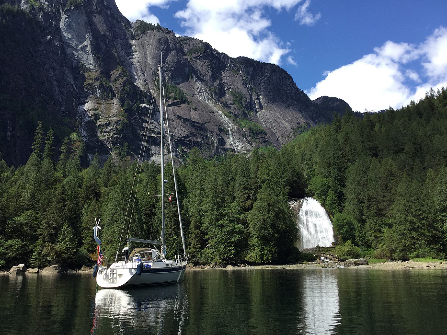
After an hour and a half we found ourselves at the top of the trail where the remains of a log cabin rested next to an impressive waterfall.  Bob drew my attention to tree scars and devastation from rocks that come down from above.  He noted that it wasn’t a very smart place to build a cabin.

Returning to the boat an hour or so later, it was sunny and warm.  We jumped at the chance to do laundry and take showers.  Each of us started with a teapot full of hot water and added it to a bucket with enough cold water from the stern shower to give us a bucket of warm water.  We lathered up and scrubbed ourselves and a weeks worth of dirty laundry, then hung the laundry on the life lines to dry in the sun and handed the bucket off to the next person.  There is a hot water heater on board that is warmed by the engine or shore power, but since we hadn’t used the engine or had the luxury of shore power for a couple of days, the tea pot method worked nicely.

Day 6 - Anchoring in Princess Louisa Inlet; Rod

In a trip likely to be flush with first experiences, we can report one in the way we anchor at Princess Louisa Inlet.  There are several moorage options in the inlet.  The easiest is the public dock at the head of the bay.  It is also the most expensive; put $20/night  in the slot please.  The next easiest is to tie up to a mooring ball: $10.  These prices likely reflect their relative cost to maintain, although the funds are probably used for other things as well.  The inlet is mostly deep (sheer cliffs into the water and beyond in many places), so the anchoring techniques reflect that reality.

At the head of the Inlet is a waterfall: Chatterbox Falls.  For the purpose of the anchoring technique we used in the inlet any river outlet will do.  Where the rest of the inlet is deep, the head of the bay has a band near the shore line that is relatively shallow, although it does get deep quickly by comparison to most anchorages.  If you anchor in this shallow area close to shore and adjacent to the falls (or river outlet), the water outflow will keep the boat aligned perpendicular to the shore and will keep the boat away from the shore, even when the tide comes flooding in.  The boat will fish around a little at times, but the motion isn’t noticeable.  This was the first opportunity we had to practice the technique on this trip and it kept us pretty secure  for our two night stay.


The other option commonly used in the deep anchorages of British Columbia and southeast Alaska is to drop the anchor close to shore and tie a line from the stern to a ring or a tree on shore.  This technique keeps the boat from swinging and therefore allows more boats to be anchored in closer proximity.  We used this option extensively in the Mediterranean (where it is referred to as Med mooring).   Quijote has 600’ of 1/2” floating polypropylene line and a garden hose reel on board for this purpose.

Day 5 - Imaginary Thieves and Real Military; Rod


Thunder Bay!  Our staging point for Princess Louisa Inlet.  I had in mind a remote, secluded little bay; rarely visited by anyone but the occasional boater.  The reality is that the shore is lined with small cabins and a boat ramp or two.  It does offer protection from the wind and is probably popular with the yachties when summer gets into full swing.  For now it is nice to have the bay to ourselves, even if we do have to share it with the locals.

Tonight we have lasagna and green beans in mind with warm bread and good company.  Simon and Garfunkel are serenading in the background.

I drifted to sleep last night, imagining Canadian mercenaries drifting silently up to the boat in a small skiff and cutting our dinghy free.  I wondered whether we'd be able to buy another in Campbell River, and berated myself for not securing the dinghy with a steel cable and padlock.  In the bright light of day it all seems a little silly.  Fatigue and darkness take the mind in funny places - not that we won't secure the dinghy with lock and key at times along the way.

Crossing the Straight of Georgia yesterday was a mixed bag.  We exited Silva Bay at a leisurely  hour anticipating having to make way against the current in Georgia Straight.  This was by design as it would give us wind and current flowing in the same direction: a little slower, but much more comfortable.  The winds were predicted to die down in the afternoon for our crossing from Nanaimo to Malaspina Straight.

The night before, I dug out the book and recorded the coordinates of the corners of the Canadian Military exercise area (WG, known locally as Whiskey-Golf).  Then I ploted the corners as way points and plotted a course around the area on the chart plotter.  A typographical error in the book for the coordinates made me use Bob's iphone to pull up the coordinates on the internet.  (123deg 47'70" is not a legal coordinate and should be 123deg 47.70').  Later we saw that various sources plot the boundary of WG differently as well (see images).

Entering the Straight of Georgia that morning we were hit by 14-16 knot winds dead ahead and 3-4' chop (a very good thing the 2 knot current was not opposing) that gave us quite a ride, but not much opportunity to do any sailing.  I tried that game 25 years ago and found reference points on land stayed stationary.

As the day wore on the chop and the wind moderated and we glided north of Nanaimo toward the way point that would take us around the corner of Whiskey Golf.  Ten minutes or so after rounding that corner we were hailed by the Canadian Coast Guard on channel 16 informing us that we had entered an active military area and asking us to depart the way we had entered.  They told us we could transit the straight by going around the Balinas Islands.

We complied of course, but reviewing the material afterward in the Douglas book  shows 2000 yards of clearance inside the islands that we should have been able to use.   The chart shows the boundaries through the middle of the Balinas Islands, so that's the source we should have used.  Live and learn.

Day 5 - Wine Hitch; Bob


It seems like knots are everywhere on the Quijote.  Today Kay added another one with an original design born of necessity.  Her Wine Hitch ™ uses two loops with a center stay to form a secure harness for cooling wine in the cool waters of the Inside Passage.  This flash of inspiration came to Kay at the base of Chatterbox falls in Princess Louis Inlet.  Here a steady flow of cool water from the waterfall is ideal for cooling a bottle of Riesling. We think this knot will come in handy in the days ahead too!

(written by Bob)